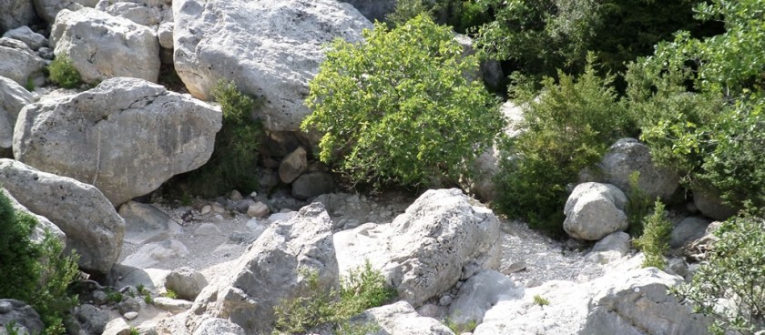
This dramatic circular route visits the narrows (Gubies in Catalan) of the Vallfiguera’s steep ravine.
Images sources: © ecofincalofavaret.com
-
#Nature Trails
Location of Start - 40.846306, 0.354139
Distance - 10.6km.
Ascent - 603m
Walking time and total completion time including any stops - 5,5/7hrs.
Start point - Take the T-341 west from Tortosa through Roquetes, in the direction of of els Reguers and Alfara de Carles. Some 7km beyond els Reguers the road takes a sweeping turn to the right. Take the left turn at the apex of this bend and, after a further 4.5km, enter the hamlet of Toscar. The parking place is immediately below an electricity substation and has some prominent els Ports information boards.
| Carry on along the road to pass by the small chapel of Santa Magdalena and the springs of Toscar. At the first signposted junction continue straight on in the direction of Font delRouret/Barranc del Toscar. The route leading up to the right, marked in red and white is the GR 171 path, which will be our descent path at the end of the circuit. | 5min, 0.43km |
| At a second signposted junction five minutes later, take the unsignposted right hand forkand continue on the dirt road, zig-zagging gently up towards the long ridge which separates Toscar from the Vallfiguera. The next fork is close to the road’s end. Bear righthere. In fact both branches join up to form an elongated turning circle for vehicles. | 25min, 1.8km |
| Two paths lead off from the end of the road to reach the ridge. Ignore the steeper path to the right and carry straight on to rise diagonally up the hillside and reach a col which gives the first view of the Vallfiguera below. | 40min, 2.4km |
| Over the col bear right and, ignoring a path joining from the left, descend with the path becoming more overgrown and steeper. Ten minutes from the col care is needed to spot cairns marking a left hand bend as the path heads more determinedly downhill. | 50min. 2.8km |
| The descent eases as the path bears right, ascending slightly as the barranc floor rises to meet it. At the next junction take the right path to converge gradually with the barranc. | 1hr 16min, 3.9km |
| The path disappears as it enters the barranc. | 1hr 30min, 4.3km |
| Turn right to head up the barranc. The going is rugged in the barranc requiring scrambles over large boulders and up small rock steps. Red paint marks indicate the easiest ways through, which sometimes means leaving the barranc floor to find passageson the valley side. After an enjoyably strenuous 20 minutes a flat area, the Pla de Llarers, is reached where a small metal signpost indicates onward for the Gubies and leftfor Mont Caro. | 1hr 50min, 4.7km |
| Continuing up the barranc at this point leads into the Gubies themselves. A truly spectacular diversion into the narrows, ending at a pool below the last abseil of the barranc. Allow an extra hour for this excursion and the return to the junction. No GPS guidance is possible or necessary here.To continue the walk, return to the Pla de Llarers with its small metal signpost and take the path indicated for Mont Caro. This is the ‘pujador’. It climbs very steeply up through the wooded valley side for 15mins or so, before bearing right on an easier gradient. The going is then easier as the path winds below tiers of steep cliffs on a balcony route paralleling the ravine. It crosses a side barranc just below the ‘Salt de Ximenot’. A dramatic cliff split by a waterfall (wet weather only). | 2hrs 40min, 6km |
| After crossing this side barranc the path rises again to cross a small col. Now care is needed to locate a junction with a small path to the right, marked with a cairn. Turn right here. | 2hrs 50min, 6.5km |
| (If this right turn is missed, just continue along the main path until it descends to meet the barranc at a junction with the red and white waymarked GR171. Turn right onto the GR and cross the barranc. After 15mins this will reunite with the route at a flat-topped outcrop.)After turning right the small path descends steeply and crosses the barranc de Vallfiguera once again. The crossing is just a few minutes easy scrambling upstream of one of the impressive abseils used by canyoners. | 3hrs, 6.7km |
| A cairn marks the small path which leads up and out of the bottom of the barranc. Careful route finding is needed to stay on this path which zig-zags up through thick vegetation; fortunately it is well-cairned. The last few metres climb more directly up to aflat-topped outcrop to join the wide and very clear GR171 which is waymarked in red and white. | 3hrs 25min, 7.2km |
| Turn right to follow the GR171 to reach the signposted Coll de Vallfiguera. | 3hrs 40min, 8.5km |
| Now the path leads down into the Toscar valley. At a signposted junction 5mins from thecol continue on the main descent path following the sign for the Toscar parking. The path weaves its way scenically over side ridges, round cliffs and by pinnacles before descending steeply back to the junction with the road where the circuit began. Turn left here to follow the road back to the car park. | 4hrs 30min, 10.6km |
Information sources: © walksinspain.org

