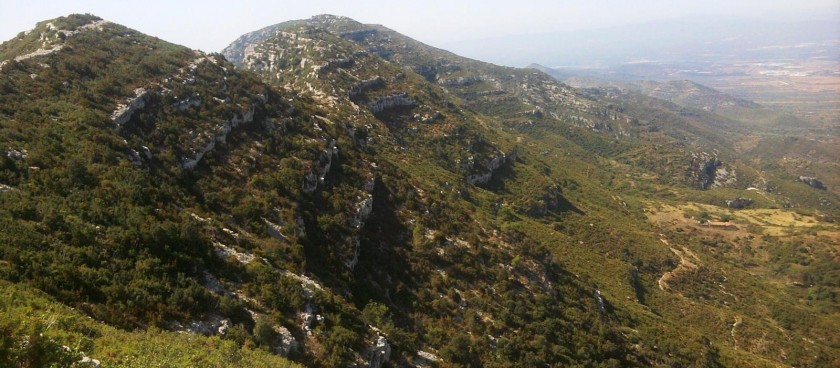
A round over the hills of Montsia to a Forat (large hole in rock) and extensive ruined Masia with panoramic views out to the coast and inland to the main Els Ports mountains.

Image source: © ca.wikiloc.com
-
#Nature Trails
Location of Start - 40.64016, 0.55729
Distance - 10km.
Ascent - 608m.
Walking time and total completion time including any stops - 3.25hr / 4.5hr
Start point - Exiting the AP7 motorway at junction 41 turn S on the N340. Pass km 1073 and look out for a minor crossroads about 500m past this where you turn R on the Cami de Mata Redona – also the name of the ruin you will see on the walk. Follow this, ignoring side turnings to its end where there is a parking area for about 15 cars.
Remember that you use these walk guides at your own risk. Take precautions and if unsure – turn back!
| Exit the car park near the end of the tarmac road along a broad footpath indicated with a finger-post towards La Foradada that zigs to the L and then climbs a little to arrive at a T-jnc. where you turn R uphill for a few metres. At a finger-post indicating La Foradada and L Rueda carry straight on on a rough and rocky footpath climbing straight up the mountain. | 470m, 8min |
| Soon the slope eases a little as you turn R across the flank of the mountain and after some time arrive on a plateau where you meet another footpath at a T-jnc. Turn L here and continue to climb up the hill now following Y/W markers soon cresting the ridge and walking along it towards the craggy crest in front of you on the ridge. This hides the foradada – a hole in the rock – which you will only see when you arrive immediately in front of it. |
1.3km, 31min |
| For now though you arrive at a finger-post with a descending path to your R which you ignore and a steep footpath rising up ahead of you which the finger-post suggests will take you in 10 minutes to the foradada. | 2.2km, 52min |
| Climb up this and emerge at another finger-post where the foradada opens up in front and below you with panoramic views through the opening. You can explore all around it and in particular on the ridge a little to its L. | 2.4km, 58min |
| However once finished you must return to the finger-post in front of the foradada and – facing the foradada – turn R to continue on a R/W signed footpath descending on the R flank of the ridge towards a circular water tank on the ridge line. Just before reaching this you reach another junction with a finger-post indicating the Mas de Mata Redona downhill to the R at a distance of some 1.35km. Take this descending path. Pass a further T-jnc. With a finger-post indicating that the Mas is still 500m ahead where we continue straight on. Pass a further T-jnc. With a finger-post indicating that the Mas is still 500m ahead where we continue straight on. |
3.1km, 1hr 12min |
| Just before arriving at the Mas (which must have contained several dwellings – all now in ruins) we reach a small wooden post on the L and here we turn L towards Freginals (5.6km) and we follow this path across a meadow. | 4.3km, 1hr 33min |
| You are now following occasional white paint marks soon rising again to crest a col where we follow the ridge line down slightly R. Arrive at a standing stone where the path swings slightly L and descends steeply aiming for a rocky col below us. | 5.6km, 1hr 58min |
| Reach this and ignore the path going off downhill to the L at a cairn. Instead continue ahead rising a little again before quickly starting to descend steeply again in zig-zags aiming for pasture land below us at a col with a ruined wall in evidence. When you arrive at an open terrace there is an obscure junction with a path going off down to the L. Ignore this and continue ahead along the grassy terrace soon rising gently and swinging L to an open area with a ruin off slightly to the L of us. Follow the path descending more steeply for a few metres to reach a confusing open area with a path crossing us. Follow this to the R soon with R/W markers soon below imposing crags |
6.8km, 2hr 23min |
| This undulates gently before descending to reach a junction where our return route turns L towards Coc de Jordi. (We can continue for 310m to the Font del Bulgar where there are also ruined Forns de Calc (limestone kilns) and then return to this junction. This excursion is included in times and gpx track) | 7.5km, 2hr 35min |
| Follow this path down with one or two zig-zags and then cross the barranco ignoring a path going off to the L as we cross and continuing ahead on the narrow track. Finally reach the finger-post where at the start of the walk we went up steeply to the R, and where now we turn L for a few metres before going L again and returning to the car park. | 8.7km, 2hr 56min |
Information sources: © walksinspain.org